
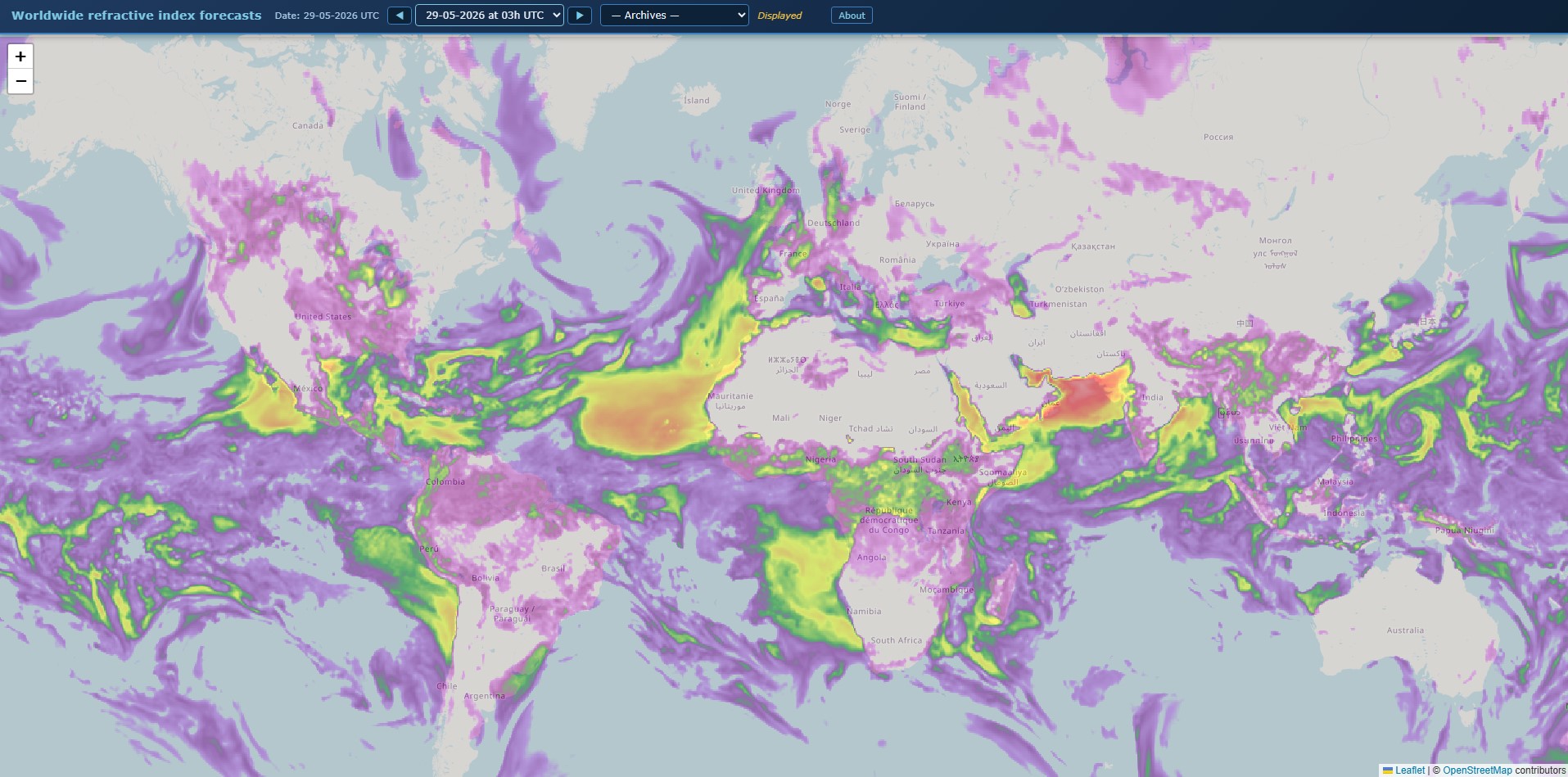
Pascal Grandjean, F5LEN, released a major update to its global tropospheric propagation forecast tool on 28 May 2026, available at tropo.f5len.org/WW/The tool has been one of the most used free tools for 2018. VHF operators planning to operate in the 50 MHz, 144 MHz and 432 MHz bands.
V článku sa dočítate
Troposferické šírenie a index refrakcie
Tropospheric propagation is a mechanism in which sudden vertical changes in the moisture content and temperature profile of the atmosphere allow UHF and VHF signals to propagate hundreds to about 2,000 km beyond the normal radio horizon. In the ducting mode, the range can be even greater. The inversion layer, which is the basic prerequisite for this mechanism, typically occurs at heights of 100 m to 1 km (non-ducting) or 500 m to 3 km (ducting) and lasts from several hours to several days. The propagation attenuation can drop below the free space value, which in practice means that distant stations receive a significantly higher signal than would correspond to the geometric distance.
A key physical parameter is the atmospheric refractive index expressed in N-units. This is the parameter that F5LEN calculates and displays on an interactive map. High values of N-units in the ground layer of the atmosphere indicate an increased probability of tropospheric above-standard conditions on VHF.
What makes the F5LEN tool useful?
Unlike generic portals, F5LEN provides a directly interpreted output for amateur radio operations. The data is updated four times a day, at around 02:00, 08:00, 14:00 and 20:00 CEST. Each dataset is approximately 4 MB in size and is rendered as an overlay on an interactive OpenStreetMap / Leaflet map. Clicking on any point on the map displays the local average refractive index value along with the Maidenhead grid locator – allowing you to directly read the conditions for a specific QTH or planned link route.
The map covers the entire world from 80° S to 80° N. The left menu contains forecasts for the nearest dates, the archive goes back one month. European forecasts are based on the ARPEGE model from Météo France with a horizontal resolution of 7.5 km and vertical coverage from 2 m to 1,500 m, which is crucial for calculating ground refraction.
New version: what's changed
The May 28, 2026 update brings four specific changes.
Stepwise control of a predictive time series
The two ◀ / ▶ buttons allow you to scroll through the forecasts directly without having to open the drop-down menu. The control is synchronized with the selector and automatically deactivates at either end of the forecast range. This covers 40 steps, which corresponds to approximately five days in three-hour intervals.
Smart preloading of GeoTIFF layers
After loading the active layer, the browser automatically downloads two adjacent prediction steps (N+1 and N-1, then N+2 and N-2) in the background with a controlled delay between requests to avoid congestion on the connection. On subsequent browsing, these layers are displayed immediately from the memory cache. On mobile devices or slow connections, preloading remains conservative and does not interfere with the active user request.
Responsive layout
The map now fills the entire available height of the viewport regardless of screen size, including mobile devices.
Fix layer display
Layer removal is now handled by direct object reference instead of the previous opacity lookup, eliminating a class of potential display artifacts that could have been introduced when quickly moving between prediction steps.
Tool parameters at a glance
| Parameters | Value |
|---|---|
| Displayed quantity | Atmospheric refractive index (N-units) |
| Update frequency | 4 times a day (approx. 02:00, 08:00, 14:00, 20:00 CEST) |
| Forecast range | 40 steps × 3 hours ≈ 5 days |
| Archive | 28 days ago |
| Geographic coverage | 80° S – 80° N, the whole world |
| Source model (Europe) | ARPEGE, Météo France, resolution 7.5 km |
| Map | OpenStreetMap / Leaflet, interactive |
| Dataset size | ~4 MB / layer |
| Target zones | 50MHz, 144MHz, 432MHz |
| Access | Free, non-commercial use |
Practical use for VHF operators

The tool is primarily used for planning operations on the 50 MHz, 144 MHz and 432 MHz bands. For operators in Central Europe, the European section with the ARPEGE model is relevant, which, thanks to the 7.5 km resolution, can also capture local differences in the refractive gradient. The 28-day archive allows for retrospective verification of whether the conditions were predicted correctly when an interesting band was opened - which is useful for calibrating your own map evaluation.
Before a DX activation or contest on VHF, it is worth checking the 5-day forecast to see if an area of increased refractive index is forming over the relevant routes. The N-units forecast itself does not determine whether an opening will occur, but it indicates the atmospheric conditions that allow for it.
"The tool is intended for use by the amateur radio community for path planning on the 50 MHz, 144 MHz, and 432 MHz bands." – Pascal Grandjean, F5LEN
The tool is run by Pascal Grandjean, F5LEN, as a private project for the amateur radio community. The content is freely available for personal, non-commercial use only. Feedback and bug reports are welcome via the contact form on the author's website.